Urban Methane Mapping Reveals Unexpected Pollution Sources
Researchers from Montreal‘s McGill University have discovered that methane emissions across the city are unevenly distributed, with the highest concentrations located in the eastern sectors, according to their recently published study. The comprehensive four-year survey identified more than 3,000 methane hotspots throughout the urban landscape, with inactive landfills and the city’s primary snow dump facility emerging as significant contributors.
Surprising Emissions from Unconventional Sources
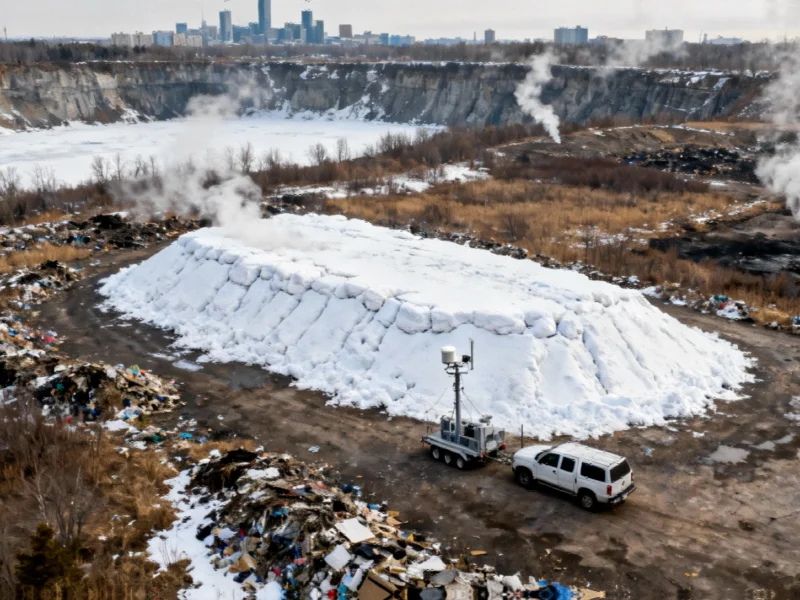
The research team reportedly expressed surprise at discovering that the Francon Quarry, which serves as Montreal‘s largest snow dump, emits methane at rates comparable to the city’s current and former landfill sites. “It’s as large as some of the other landfills. A ton of stuff is dumped there, stuff that’s picked up off the roads,” said Peter Douglas, Associate Professor in the Department of Earth and Planetary Sciences and study co-author, as quoted in the research documentation.
Analysts suggest that as accumulated snow melts at the quarry site, it creates a lake environment that potentially harbors microbes capable of releasing additional methane. This finding challenges conventional understanding of urban methane sources and indicates that municipal snow management facilities may represent previously overlooked emission hotspots.
Methodology and Persistent Hotspots
The research team conducted mobile surveys across 3,300 square kilometers of the city over multiple years (2019, 2022-2024), using advanced monitoring equipment that measured carbon dioxide and methane levels every second. According to reports, Environment and Climate Change Canada conducted much of the testing by vehicle, while local bikeshare service BIXI provided complimentary memberships to assist with the research effort.
Sources indicate that three fixed routes were surveyed weekly for 10 weeks, enabling researchers to track how methane emissions changed over time. “We’d see an increase in concentration and then it would come back down, so we could figure out approximately how much gas was coming from that source and locate where it was,” Douglas explained in the study documentation.
Climate Implications and Infrastructure Concerns
The research findings carry significant implications for climate policy, given that each methane molecule reportedly warms Earth by approximately 32 times as much as every carbon dioxide molecule. “We need to know where these emissions are coming from to resolve them,” Douglas emphasized in the published research.
The report states that the highest methane concentrations were found in areas with older natural gas infrastructure, particularly in Montreal‘s east end. “Most gas leaks are concentrated where we use this older infrastructure,” Douglas noted. “But we really focused on population density. With more people, there are more natural gas lines and more leaks.”
Research Context and Future Directions
The mobile monitoring survey was designed to provide robust data to help Quebec achieve its goal of reducing greenhouse gas emissions by 37.5% by 2030. Unlike municipal emissions inventories, which rely on estimates, this research employed direct measurement techniques to pinpoint specific emission sources.
The complete study has been published in Environmental Research Communications, providing detailed methodology and findings. Researchers indicate the ongoing project will soon track seasonal changes in methane concentrations and explore how surface bacteria at landfill sites might help mitigate emissions.
This urban methane mapping research comes amid growing scientific interest in understanding urban greenhouse gas emissions, paralleling developments in other technological fields such as AI-powered robotic systems transforming chemical processes and computational advances like those detailed in reports about AMD’s Zen 5 architecture developments. As urban environmental monitoring evolves, similar approaches may be applied to other cities worldwide, potentially influencing how municipalities track and address climate pollutants.
This article aggregates information from publicly available sources. All trademarks and copyrights belong to their respective owners.
